Treasure Island Master Plan

Treasure Island Master Plan

Designed to provide new housing in the San Francisco Bay, this master plan transforms a former naval base into a walkable community surrounded by a restored wetlands ecology.

Project Facts
  • Status Design Complete
  • Design Finish Year 2011
  • Size Site Area: 393 acres
  • Condo Units 8000
  • Keys 500
  • Sustainability Certifications LEED ND Platinum
  • Collaborators
    Arup Perkins&Will - Dubai AECOM CMG Landscape Architects Engeo Incorporated Baldauf Catton Von Eckartsberg Architects Hornberger + Worstell Page & Turnbull Mithun Gibson, Dunn & Crutcher Llp SWCA Environmental Consultants (Turnstone Consulting)

A new chapter for a landmark island

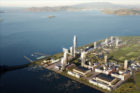
Treasure Island, a California Historical Landmark in the San Francisco Bay, is a human-made island originally built for the 1939 Golden Gate International Exposition. Upon its opening, the island featured expansive fairgrounds, exhibit halls, airplane hangars, a federal building, and a 12,000-car parking lot. By World War II, the U.S. government had established a naval station on the island, which remained in operation until 1997.

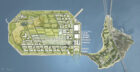
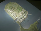
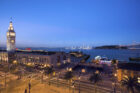
Following the decommissioning of the naval station, Treasure Island presented a compelling opportunity to address San Francisco’s need for housing. In 2005, SOM signed on as Master Architect to transform the 393-acre island into a new, mixed-use district.

Sustainability and open space are the core principles of the master plan. Arranged as a series of high-density, residential neighborhoods with retail, hospitality, and offices, Treasure Island features a mix of low-, mid-, and high-rise buildings and approximately 300 acres of open green space—about 75 percent of the island. New and improved modes of transit, walkable streets, solar energy infrastructure, and restored wetlands work in tandem to keep Treasure Island resilient and minimize carbon emissions.

© SOM

Creating a transit-oriented community

The plan establishes three compact, walkable residential neighborhoods carefully integrated alongside Treasure Island’s historic buildings facing Yerba Buena Island to the south. The development is designed to accommodate more than 550,000 square feet of commercial space and up to 18,000 residents. The layout of the streets promotes walking, bicycling, and transit by bus, shuttle, and ferry, connecting most of the island within a 15-minute journey.

Island Center is the development’s highest density neighborhood, featuring residences, community spaces, a market plaza, private docks, and a retail-lined main street that leads to an alley enlivened by public art installations. A new ferry terminal, relocated to face the city and reduce ferry rides to eight minutes from the Embarcadero, is directly accessible from Island Center. The neighborhood is the first component of a multiphase development project—planned through 2041—and began welcoming ferry service in 2022.


Planning a resilient, low-carbon future

The master plan transforms Treasure Island into a model of sustainability and environmental stewardship. A careful study of the island’s wind, sun, and fog patterns informed key design decisions.  The buildings are clustered at the island’s edges to temper the bay’s strong winds and maximize sunlight in the central public spaces, which include organic farming, native landscaping, recreational trails, and sports fields.

The development is designed to exceed California’s Title 24 Building Efficiency Standards. Shaded walkways and windows, reflective roofs, light-colored paving, natural ventilation, and solar energy absorbed through rooftop photovoltaics contribute to a significant reduction in energy use. Around the island, water conservation measures such as xeriscaped gardens, grass-filled pavers, graywater recycling systems, and on-site stormwater treatment facilities help the development use water efficiently and protect the buildings from flooding.


Solar-oriented public spaces. © SOM
Wind-protected public spaces. © SOM

More Projects

01/